How to find your way around a DCO application
 Today's entry sets out how to understand an application for a nationally significant infrastructure project.
If you are affected by a large infrastructure project that must use the regime created by the Planning Act 2008 for the first time, it can be a daunting task finding your way around the application documents. This entry tries to help.
You may have received a leaflet or a letter about an application, heard reports in the media or been told about it by neighbours or community groups. The first and main port of call to find out more about the project and what stage it has reached is the national infrastructure website infrastructure.planningportal.gov.uk.
There is a search box on the middle right of the screen and if you type a few letters from a project name, the projects containing those letters will appear below. Click on the one you're interested if it comes up and click 'Go'.
- See more at: http://www.bdb-law.co.uk/our-insights/blogs/planningact2008blog/2014/01/523-how-to-find-your-way-around-a-dco-application#sthash.W88OW851.dpuf
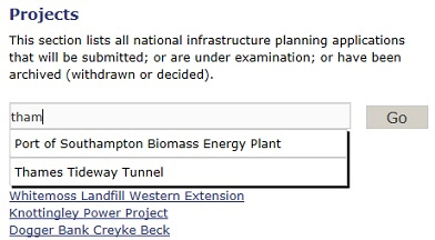
If it doesn't come up you are either using the wrong name for it (some projects have several nicknames) or it isn't (yet) on the website at all. To run your eye down the complete list of projects at any stage (118 to date), click on the blue 'Projects' button to the top left of the screen (not any of the drop down entries) and you will see a full list 10, 25, 50 or 100 at a time, which you can change using 'show [ ] entries'.
If your project isn't in the list then it may either not be using the Planning Act 2008 to get consent or be at such an early stage that no official steps have been taken. You will have to find out more about the project on the internet of from asking around.
Now I will describe the main application documents, assuming an application has been made.
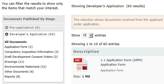
Once this has happened, which is the case for 44 cases so far, there is a reasonably common set of application documents. Get to the main project page as described above, click on the 'Documents' tab and then the 'Developer's Application' filter on the left and 'All documents'. Here are the main documents you will probably be interested in.
- See more at: http://www.bdb-law.co.uk/our-insights/blogs/planningact2008blog/2014/01/523-how-to-find-your-way-around-a-dco-application#sthash.W88OW851.dpuf
Where is the project? The location of what will be built is shown on the 'works plans'. Start typing 'works plans' in the 'Filter:' box on the right to find them and click on them. These plans show where each part of the project will be built. The project is usually divided into a number of numbered 'works', which are shown on the plans.
For a written description of each work you will have to look at the legal instrument that will authorise the project, the Development Consent Order or DCO. Find the DCO either by clicking 'Draft Development Consent Orders' to the left or starting to type 'Development Consent' in the filter box. The DCO is fairly difficult to understand for a non-lawyer, but scroll down until you get to 'Schedule 1' and you will see a description of each numbered work corresponding to what is shown on the works plans.
If you think or know that you are having some of your land acquired or its value may go down as a result of the project you can check this by looking in the 'Book of Reference'. To find that, click 'Compulsory Acquisition Information' on the left or start typing 'Book of Reference' in the filter box. This may be one or more than one document. In each case you can search for your name or company. If it is there, and when it is mentioned there is a plot reference in the first column, then you are having some land acquired or used. If there is no plot reference then you are not having any land directly affected, but the effects of the project may mean you have a claim to financial compensation. To see where the plots are you will need to look at the 'Land plans'.
The land plans are similar to the works plans in that they show (more or less) the same land, but divided into land ownerships rather than showing where the works will be. Usually, the first part of the plot reference will be the sheet number of the land plans that the plot is shown on, but not always. Usually, if your land is to be acquired permanently it is shown pink on the land plans, if it is only to be occupied temporarily it is shown green or pale blue, and if a right is to be created across it (like a right of way or the right to install a pipeline) it is shown dark blue, but again practice varies. You can double-check this in the DCO, which is likely to have a schedule showing what plot references are to be temporarily occupied and another one showing what plot references are to have rights created in them.
To find out why the land is being acquired or used, you need to look at the 'statement of reasons', another document that forms part of the 'compulsory Acquisition Information'. This should describe the project in general terms and explain why there is a 'compelling case in the public interest' to acquire each plot of land, the test that the project must pass.
That is the physical location of the development and its effect on land ownership and occupation, but what about environmental effects? The main document for those is the 'Environmental Statement' (ES), which is likely to have been split into several documents on the website. Most of these will be technical appendices and plans, and you need to find the main text of the ES. The Planning Inspectorate still isn't loading these in the correct order, but one of the documents will be the main text, and will either be called 'Environmental Statement' or 'Main text' or 'Volume 1' or something like that. There should also be a 'non-technical summary' of the ES, which is supposed to be in plainer English.
ESs are divided into chapters by type of impact rather than location, so for different impacts at the same location you will have to look at each chapter. Generally, ESs set out the 'baseline', which is the environmental situation expected to be obtaining at the start of construction, then what the impacts of the project (both construction and operation) are expected to be, and then the 'mitigation' proposed (i.e. how the developer is proposing to reduce the impacts, by building noise barriers and such like). There may still be some significant impacts after mitigation. You should be looking for (a) whether you agree with the mitigation that is proposed, (b) how you can be sure that it will be delivered and (c) what the developer will do if in fact the mitigation doesn't work or there are still adverse impacts after mitigation.
Some projects are too small to have an ES, but those are rare, given that these are all nationally significant infrastructure projects.
Those are really the main documents you need to know about. Even if you aren't affected by a project at the moment, you could have a look at some of the projects currently being examined to get a feel for how they are organised so that you can hit the ground running when your project comes along.
That was all a bit dry. It might be better presented in a video with someone navigating the website as they speak; I hope something along these lines is planned for the Planning Inspectorate youtube offering.
- See more at: http://www.bdb-law.co.uk/our-insights/blogs/planningact2008blog/2014/01/523-how-to-find-your-way-around-a-dco-application#sthash.W88OW851.dpuf